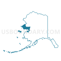
Gambell Precinct, Nome Census Area, Alaska
About
Outline

Summary
| Unique Area Identifier | 523472 |
| Name | Gambell Precinct |
| County | Nome Census Area |
| State | Alaska |
| Area (square miles) | 858.09 |
| Land Area (square miles) | 497.72 |
| Water Area (square miles) | 360.37 |
| % of Land Area | 58.00 |
| % of Water Area | 42.00 |
| Latitude of the Internal Point | 63.49780830 |
| Longtitude of the Internal Point | -171.42909050 |
Maps


Graphs
Select a template below for downloading or customizing gragh for Gambell Precinct, Nome Census Area, Alaska